Tuesday, April 2, 2019

Bicycling at Maurice K. Goddard State Park, Pennsylvania

Maurice K. Goddard State Park is located just north of the town of Sandy Lake.  The reservoir was created by the damming of Sandy Creek.  The park is easily accessed via I-79.

There is a paved trail around part of the lake, which combines with low traffic park roads to make a really nice loop just over 12 miles in length.  This trail is not like a rail trail, with gradual grades and curves.  Instead it's a purpose designed bike trail, with many curves and hills, which goes through woods and meadows around the southern end of the reservoir.  The loop can be a lot of fun for experienced cyclists, but if you're thinking of taking your mother who hasn't ridden a bike in 15 years there, the hills are going to put them in granny gear a lot and they probably won't enjoy themselves.

Maurice K. Goddard State Park info

Near the beginning of a clockwise loop of the trail.

One of about 6 trailside shelters, good for a rest or waiting out the rain.

The trail and Lake Road alongside.

Peaceful rest area along the trail.

You can see the ups and downs along the trail.

Wild chives growing trailside.


Approaching the dam at the south end of the reservoir.

Looking downstream at Sandy Creek.

Looking upstream at the lake.

Where the trail moves onto the road for a mile or so. Hiking trail is 'no bikes'.

Crossing the road away from the lake.  This is where the 2 biggest hills are.


Where the loop uses the Marina roads for 1/4 mile.

Viewing platform on north side of Lake Wilhelm Road, near Marina.


From viewing platform.

Lake Wilhelm Road at Marina, and the view of the bridge across the lake.

Lake Wilhelm from the bridge.

And back to the trailhead parking area.


Thursday, March 14, 2019

Hiking at Clear Creek State Forest, Kennerdell Tract, Pennsylvania

The Kennerdell Tract of Clear Creek State Forest is located a short distance north of I-80 on the west banks of the Allegheny River.  This location means its the closest public land with open back country for many northeast Ohio residents.

It is known for the wide range of outdoors activities available, including hiking, camping, backpacking, mountain biking, and horseback riding.  It also makes a good spot for paddlers heading down the Allegheny to spend the night, as it's located right on the river.

The hike featured today started at the parking area at the end of Dewoody Road, and followed the access road to Iron Furnace Trail, then Overlook Trail and Dennison Run Trail.

For video highlights go to the Getting Out There Youtube channel:

GOT - Hiking at Kennerdell


Trail and parking map.

Iron Furnace Trail.

Wintergreen berries growing near ground pine.

On Iron Furnace Trail.


Needle ice on the trail, still frozen under the leaves.  About 4" long.

Allegheny River and Kennerdell from Dennison Point Overlook.

Info board at Dennison Point Overlook.

Looks like a damaged trail - really just leaves stuck on melting needle ice.

Heading down into Dennison Run.


Done with the descent, turning uphill along Dennison Run.

The first hikers bridge across Dennison Run.


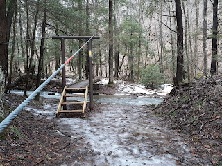
Further up Dennison Run Trail, a hiker's bridge across a tributary.


Dennison Run tributary.


Heading back out to the access road, back up on top of the ridge.

Thursday, January 3, 2019

Upper Bent Run Falls, Pennsylvania

With the constant wet weather keeping the mountain bike trails saturated I've been searching for new outdoors adventures.  New Year's Day I went back to Bent Run Falls, near Warren, Pennsylvania.  This time I hiked up to the first fork, and then took photos and video on the way down.  Looking at the topo map I'm guessing I was about 350 feet above the reservoir when I turned around.


First fork coming in from left of photo.


For video of the falls, go to Youtube:


Trail sign at nearby Tanbark Trail.

Enlarged view of bottom sticker - BFM!